Better accuracy and speed in on-site data acquisition for BIM


B IM solutions have resulted in high-quality projects and enabled teams to complete them in a shorter time, and at a lower cost
Building Information modelling (BIM), as a concept, first came about in the 1970s, but its methods have been refined considerably since then. Widely used by city planners, architects, and civil engineers today, BIM enables stakeholders to better make high-impact decisions by providing timely, relevant information.
According to the National BIM Standard-United States, BIM is a digital representation of physical and functional characteristics of a facility, shared as a knowledge resource to form a reliable basis for decisions during its life-cycle, which is defined as existing from earliest conception to demolition.
BIM facilitates the collaborative process of designing a building, putting varied types of information all on one coherent system of computer models, as opposed to separate sets of drawings. More than just geometry, BIM covers spatial relationships, light analysis, geographic information, and quantities or properties of building components. Today, a typical BIM file contains data that extends all the way to the ‘seventh dimension’. This includes the basic, traditional two-dimensional technical design drawings of buildings; three-dimensional (width, height, and depth) spatial drawings; ‘fourth dimension’ of time (4D BIM); ‘fifth dimension’ of cost (5D BIM); ‘sixth dimension’ of sustainability (6D BIM); and ‘seventh dimension’ of facilities management(7D BIM).
Apart from its ability to collate discrete sets of information, BIM allows data to be updated in real-time, which means various stakeholders willhaveinstant and common access to the latest information. Simply by being on the same page, companies have avoided costly mistakes of error and rework, and also enjoyed enormous benefits of time-savings and greater levels of accuracy in estimation.
Laser Scanning Technology in BIM
As the usage of BIM evolved overthe last two decades, the user community has found laser scanning technology to be useful in numerous applications. The capabilities of a modern day laser scanner have contributed much richness and texture to the information included in BIM files for architects, contractors, facility managers, and owners.
Laser scanning solutions from 3D measurement device manufacturers have shaped the way teams work together, making it easier for them to communicate, collaborate, and solve problems that may crop up in the course of a project. Overall, such BIM solutions have resulted in high-quality projects and enabled teams to complete them in a shorter time, and at a lower cost.
In practice, laser scanning solutions are used by BIM specialists for site documentation purposes, right from a facility’s structural design phase to its post-construction architectural phase. Laser scanning technology captures existing conditions in 3D within minutes, at the touch of a button. With the data, users can create 2D drawings, conduct inspections, create 3D building modelling, and even generate site plans that are registered to global positioning coordinates. Practitioners are preferring laser scanners over traditional tools such as total stations, becauselaser scanners provide them with much more detail and data points, which have proven useful when generating final deliverables of a project.
With laser scanning technology, architects can now work off real-time 3D data on their computers with much less effort – conjuring designs, manipulating drawings, or adding elevations – and all without compromising on measurement accuracies.
A quick comparison of the conventional surveying equipment and the laser scanning technology reveal that the modern laser scanner provides several advantages over traditional tools. With laser scanning technology, BIM specialists complete surveying tasks much more quickly and obtain reports with more information (e.g. resolution, position, and colour).
The following section highlights how users can benefit from using laser scanning technology in their projects.
BIM applications of laser scanning technology
2D Drawings
Many of today’s building and infrastructure projects lack in as-built documentation of the existing facility, and 2D plans or existing drawings are rarely available for old buildings. The presence of this issue has made it challengingfor planning and redesigning works to take place. In addition, theconventional total station is inadequate for capturing physical structures efficiently, since it can only capture a few points at a time. Not only is the method time- and labor-intensive, the data obtained would be incompatible with a point cloud processing software, limiting the possibilities of its usage.
3D documentation solutions like the FARO Focus3D X Series and FARO Scanner Freestyle3D would, however, be capable of addressing the need of digitisation for BIM practitioners. Both devices quickly and reliably documents objects, structures, or entire rooms with high precision, and their portability makes it easy for scans to be conducted anytime, anywhere. Post-processing ofthe point cloud data obtained by the devices can then be performed with FARO’s selection of software (e.g. VirtuSurv, PointSense, and SCENE), further simplifying and streamlining the process for users.
Structural Inspection
Structural damage to buildings can cause substantial economic losses to property owners, and can also reduce a property’s current and future value. Structural inspections enable owners to take preventative measures or to make necessary rectifications.
With traditional surveying tools, data capture for structural inspection is slow and inflexible. Moreover, the extent of damage cannot be monitored with certainty, and the evidence is documented only in 2D images.On the other hand, FARO Focus3D can provide the information required for an effective assessment.For instance, an analysis of concrete floors for slab flatness will indicate if any area needs to be adjusted, afterwhich the BIM specialist can determine the volume of material needed for that job –resulting inless wastage and a better cost management process overall.
In addition, laser scanning technology can also be used to verify that components of a building have been installed according to its original design, which is helpful for cost management, insurance claims, or legal disputes. The FARO Focus3D can perform as-built documentation with millimeter-accuracy (±2mm), capturing details such as pipes, HVAC systems, structural steel, floors, and even rebar in concrete slabs throughout a building. If any discrepancies are observed when compared against adesign, property owners can either make alterations or rectifications as necessary.
3D Building Information Modelling
Contractors of building and infrastructure projects often do not keep a record of current construction or maintenance documents of the existing facility. Yet, toacquire digital survey data of a large spaceby utilising conventional methods would be too time-consuming and laborious. In any case, the incompatibility of the data acquired would have made it difficult for the team to import the information into any of the popular CAD programs available in the market.
In a similar fashion to which 2D drawings can be generated from the scans obtained by FARO Focus3D, producing 3D building information modelling is also a breeze with FARO 3D documentation solutions. The FARO VirtuSurv software acts as a flexible interface to allow users to import and export scan data for use on various platforms. The FARO PointSense Building software, an AutoCAD plug-in, then efficiently processes the 3D scan data with a range of available tools, which allows auser to manipulate the information for specific project deliverables.
Success stories of FARO customers
On-site 3D building model creation made easy
Third Building Construction Company of China Construction Eighth Engineering Division (CSCEC83) is one of the biggest building contractors in China. In 2014, CSCEC83 embarked on a new project to construct the Jiangsu Grand Theatre and to complete the handover by June 2016. Given the large scope of the project (a total net land area of 196,633 sq.m., and total construction area of 271,386 sq. m.), to say that the team was hard pressed for time was an understatement. The unique design of the theatre further added to the complexity of the project in terms of quality control.
To overcome this immense challenge, the team decided to use the FARO Focus3D X 330. FARO Focus3D X 330 could effortlessly scan the entire curved surface and provide the team with the necessary data, thus resolving the quality control issue.
In conducting the structural testing of curved surfaces of the water droplets, the Focus3D X 330 was first used to collect the point cloud data. Next, the FARO SCENE software was used to integrate the scan data, followed by a comparison with the architectural design model on the Geomagic software to check that the various design requirements were met.
This entire process was not only fast, it was also highly accurate.
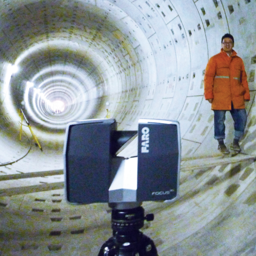
Simplifying structural deformation monitoring
Beijing Urban Construction Exploration & Surveying Design Research Institute (Beijing Urban) undertakes projects involving railway construction and detection (or monitoring) of tunnel deformation, providing independent appraisals that contribute to the safety of civil engineering projects.
There were several limitations with Beijing Urban’s older methods of data acquisition. For one, performing measurements wasdreadfully time-consuming, requiring up to 8 hours for just data collection (excluding processing and analysis). In addition, data collected with total stations was inaccurate as they were only able to register a limited number of points. The team had to rely on software to extrapolate extensively and to connect the dots so as to form any shape. For this reason, crucial data points that would indicate instability or deformation often went undetected.
With the Focus3D, Beijing Urban managed to improve on both its productivity and accuracy. The team is now also able to generate better reports for its customers, including tunnel cross-sections, histograms, and 3D model outputs. For a job that used to take 8 man hours, Beijing Urban nowrequires just 3 to 4 hours to complete.
Additionally, Beijing Urban also benefited from the portability offered by the Focus3D.
9
Cookie Consent
We use cookies to personalize your experience. By continuing to visit this website you agree to our Terms & Conditions, Privacy Policy and Cookie Policy.